


You know that feeling when you plan a dream trip, only to arrive and find the famous waterfall is nothing but cracked rock and a sad little puddle. If you have been eyeing Chiapas waterfalls on Instagram, this risk is very real.
In Chiapas, some waterfalls are bone dry for months, then suddenly turn into violent brown monsters that close trails overnight and sweep away everything in their path. Sounds extreme, right. It is, and that is exactly why you need to understand what is happening before you go.
Here you will see which Chiapas waterfalls vanish, which explode after sudden storms, how time lapse photos and local alerts can literally save your trip, and why some once iconic cascades may quietly disappear from tourism maps sooner than you think.
Where Chiapas Waterfalls Vanish Then Roar Back to Life
Let us start with the shock factor, because travelers learn this the hard way every dry season. You see the turquoise postcard of Agua Azul, you land in Mexico, and then the river looks like a dry parking lot with a few muddy pools.
Then, a few months later, one brutal storm hits the mountains and that same calm river becomes a raging wall of water that sweeps away trees, rocks and yes, sometimes parts of the trail. The exact same waterfall goes from Instagram fantasy to safety hazard.
That mood swing is not random. It is the result of extreme seasonality and deforestation in the highlands above these rivers. Once you know which rivers feed which falls, you can predict when they will be magical and when they will be dangerous or simply gone.
The Hidden Engine Behind These Violent Swings
Pense comigo, if a waterfall disappears and then comes back stronger, something upstream is broken. In Chiapas, that something is the combination of aggressive deforestation, climate change and porous limestone that soaks and releases water in strange ways.
The rainy season loads the ground like a sponge. When it is full, one intense storm sends everything crashing down ravines at once. In the dry months, that same sponge is empty, the rivers shrink, and waterfalls like Misol-Há or El Chiflón can lose most of their dramatic flow.
Hydrology studies from CONAGUA and climate reports from NOAA back this up, showing more intense bursts of rain separated by longer dry spells. Less steady rain, more violent downpours, more moody waterfalls.
Time Lapse Proof How the Waterfalls Transform Overnight
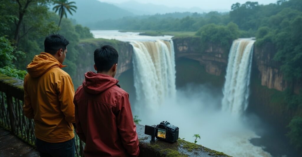
Here is the secret that smart travelers are using now, instead of guessing. Local photographers in Chiapas set up time lapse cameras on popular cascades, and the results are honestly shocking. You see a gentle curtain of water at sunrise, then by afternoon it is a brown freight train.
Some local tourism collectives share this footage on social media channels and WhatsApp groups. They show when a fall is drying out, when the color turns from turquoise to chocolate and when authorities are about to close access because of a sudden surge.
To give you a sense of the contrast, check this quick comparison.
| Waterfall | Dry Season Look | Peak Rainy Season Look |
|---|---|---|
| Agua Azul | Weak flow, exposed rocks, faded blue | Thunderous, chocolate brown, frequent closures |
| Misol-Há | Graceful curtain, easy to walk behind | Heavy sheet, intense mist, access often limited |
| El Chiflón | Clear steps, bright turquoise pools | Flooded paths, fast current, swimming banned |
Once you see this contrast side by side, it becomes obvious why planning only with old photos is a terrible idea. Time lapse and up to date images tell the truth that postcards will never show.
Reading Local Alerts Before You Chase Chiapas Waterfalls
Now we get practical. Before you chase any Chiapas waterfalls, you should check the same signals that local guides watch every single morning. This is not paranoia, it is basic survival mixed with smarter trip planning.
Here is what to monitor in the week before your visit.
- Rain intensity in the past 72 hours, especially in the highlands upstream
- River level alerts from local civil protection authorities
- Recent posts from nearby communities and guide collectives
- Official notices about trail or park closures
These clues together form a live map in your head. Three days of heavy rain with rising river alerts, you skip the tight canyons and big cascades. A quiet week with scattered showers, you are more likely to find pretty but safe flows and clearer water.
For broader weather patterns, the regional maps on NASA Climate help you see if you are walking into an unusually dry spell or an early rainy season punch.
Flash Flood Traps Tourists Fall Into
Here is where most visitors underestimate Chiapas and honestly, where I get a bit opinionated. The danger is not only at the edge of the waterfall. It often starts much further back, in the lazy looking river or in narrow gorges that feel calm and safe.
- Trusting clear skies above while storms rage upstream out of sight
- Walking onto wide exposed riverbeds for photos during low flow
- Ignoring rising noise or sudden color changes in the water
- Crossing makeshift bridges or ropes without asking local guides first
Those are the classic setups for flash flood disasters. The riverbed that was great for drone shots one hour ago can become a trap when a surge arrives. Your only real early warning is behavior watch how local vendors and guides react. If they start moving away from the water, you do not stay put.
Why Some Cascades May Vanish from Tourism Maps
Now to the uncomfortable part. Some of the most photogenic Chiapas spots you see today might simply not be there, or not be safe to visit, in ten or fifteen years. And the reason again sits upstream.
When forests are stripped for cattle or crops, the ground stops holding water. Rivers run harder and shorter, carving deeper channels and skipping those side pools that once created gentle falls. At the same time, climate change is making droughts longer and storms more violent.
The result is brutal. Some seasonal cascades will dry so often that tour operators quietly drop them from brochures. Others will be classified as too risky in the rainy season, turning them into “locals only” spots again. In practice, they vanish from the easy tourist circuit.
How to Still Capture Epic Moments Without Playing Roulette
So, how do you enjoy Chiapas waterfalls without gambling your time and safety. You build a flexible plan instead of a fixed bucket list, and you treat local information as more important than any travel blog, including this one.
- Base yourself in a hub city and decide waterfall visits day by day
- Hire local guides who live near the specific river, not generic tour sellers
- Ask to see same week photos or videos before committing to long drives
- Always have a “plan B” site that works in dry or rainy conditions
This approach may feel less romantic than a perfectly scripted itinerary, but it is much more realistic. You stop chasing a specific photo and start chasing the best conditions of that exact day. Ironically, that is how you end up with better shots and better stories.
What This All Means for Your Next Trip
When you zoom out, Chiapas waterfalls are not just pretty backgrounds. They are living mood charts of a region dealing with deforestation and a changing climate. Dry one season, overflowing the next, sometimes closed without warning, sometimes completely transformed.
If you learn to read time lapse images, local alerts and the subtle signs on the ground, you go from confused tourist to informed traveler. You stop being surprised by sudden closures and start predicting them. And yes, you still get those jaw dropping views, just without pretending the risks and the future do not exist.
FAQ
When is the Best Time of Year to Visit Chiapas Waterfalls
The sweet spot usually lands at the transition between dry and rainy seasons, around late March to early May, and again late October, when water levels are decent but not yet extreme. You get more reliable flows, less chocolate brown floodwater and fewer closures. Even then, check local rain and river alerts during the week before your visit, because one rogue storm can change conditions overnight in the canyons and at the big cascades.
How Can I Check Real Time Conditions at Chiapas Waterfalls Before I Go
Use a mix of sources instead of trusting old photos. Search recent geotagged posts on social media for each specific waterfall, then message local guides or community tourism groups for same week pictures. Check regional rain and river alerts from authorities, and ask your accommodation for on the ground updates the day before. When you arrive in the area, watch the water color and noise, and notice how locals behave. If vendors avoid the riverbed, take that seriously.
Are Chiapas Waterfalls Safe to Visit During the Rainy Season
They can be, but only with caution and flexibility. In early rainy season, flows become dramatic and photogenic, yet flash flood risk rises sharply, especially in gorges and wide riverbeds. Many accidents happen when visitors ignore rising noise or muddy surges in the water. The safest approach is to visit with a local guide who knows recent conditions, avoid tight canyons after heavy rain, and accept that some trails may close at the last minute. Never treat a posted closure as a suggestion.
Why Do Some Famous Chiapas Waterfalls Look Brown Instead of Turquoise
The dreamy turquoise color depends on mineral rich but relatively calm water flowing over limestone. After intense storms, runoff tears soil from hillsides and carries huge loads of sediment into the rivers. That turns the water into a brown, foamy torrent that can stay muddy for days. Deforestation aggravates this by exposing more bare ground. So a waterfall that looks crystal clear in dry periods can become a chocolate wall in peak rainy season, often leading to swimming bans and temporary closures.
Will Climate Change Really Make Chiapas Waterfalls Disappear
Disappear does not always mean dry forever, but it does mean some cascades will become unreliable, ugly or too hazardous for mainstream tourism. Longer droughts shrink base flows, so seasonal falls run less often and for fewer weeks. More intense storms carve deeper river channels, bypassing old pools that created picturesque drops. Combined with ongoing deforestation, this leads to fewer calm turquoise stages and more violent brown surges. Over time, tour operators quietly stop promoting those sites, effectively erasing them from most travel maps.